2. DISCOVERING AND ACCESSING DATA
Data Retrieval with Open Radar Data (ORD) API
Please note: ORD API onboarding on MeteoGate is finalised on May 20th, and whitelisting is no longer needed.
With the onboarding completed, access for ORD API will be provided through MeteoGate. More information can be found in the newsletter.
With this transition, please note the changes in the access point addresses and notification service port, the following ORD services are now openly available:
- ORD API via MeteoGate Gateway
- ORD API swagger UI
- Notification service: The MQTT connection parameters have changed: username: everyone, port: 8884
Data available in ORD API
1. EUMETNET OPERA single-site volume radar data
- 24-hour rolling cache, with a long-term archive (2012–, TBD)
- Formats: BUFR (older) and ODIM HDF5 (recent)
- License: CC BY 4.0 (with exceptions noted in metadata)
- Currently mainly includes:
- DBZH (Doppler-filtered horizontal reflectivity factor, with national QC applied)
- TH (unfiltered horizontal reflectivity factor)
- VRADH (horizontal radial velocity)
- Basic dual-pol variables (e.g. correlation coefficient, differential reflectivity, differential phase shift, specific differential phase) are planned to be added from 2027 onwards (TBD)
2. EUMETNET OPERA composite products
- Products: maximum reflectivity, instantaneous rain rate, 1-hour accumulation
- 24-hour rolling cache, with a long-term archive (2012– )
- Formats: ODIM HDF5 and cloud-optimized GeoTIFF
- License: CC BY 4.0
3. National radar products
- Examples of national composites, rain rate composites, accumulations, echo tops
- Access: via links to national interfaces (24h access of links)
- Formats: ODIM HDF5 or cloud-optimized GeoTIFF
ORD API Examples
The Open Radar Data API is ideal for retrieving and integrating radar data into various workflows. Here are some examples:
1. EUMETNET OPERA single-site volume radar data:
-
Retrieve single site (Hurum, Norway) radar intensity data (DBZH) in ODIM format for specific time range (2026-06-04T06:10Z/2026-06-04T06:40Z) and elevations lower than 5°:
i. Open ORD API Swagger UI and select: collections/observations/localtions/{location_id}
ii. Click to "Try it out" button and set the query parameters:
iii.
location_id: 0-578-0-nohuriv.
parameter-name: leave blank, set it below separately(standard_name:level::)v.
datetime: 2026-06-04T06:10Z/2026-06-07T06:40Zvi.
standard_name: DBZHvii.
level: ../5.0viii.
format: ODIMix.
method: scanx.
durationis blank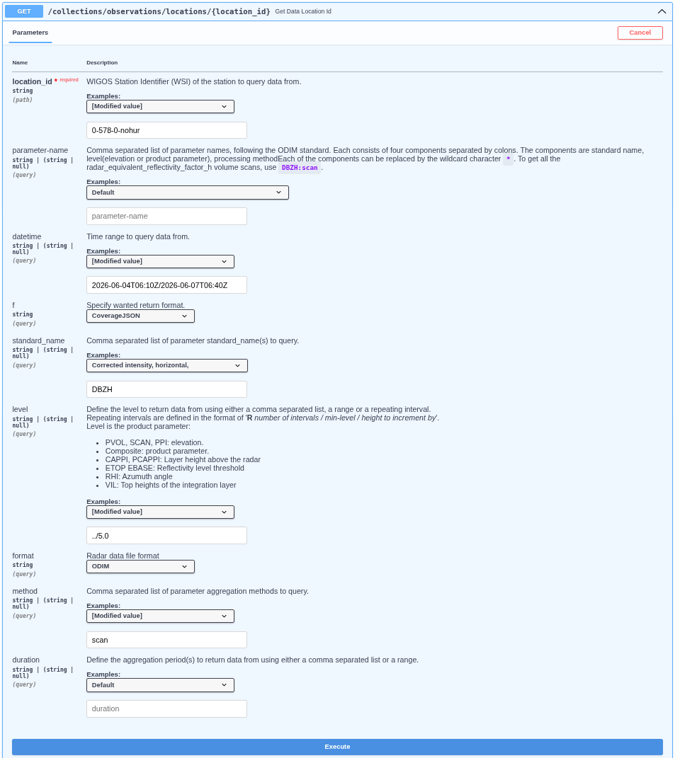
Note: Location id is
0-578-0-nohur, where578is the ISO country code of Norway, andnohuris a unique ODIM code. You can find the full list of the codes here.xi. Click the Execution button and the response available. See the
curlexample the request url and the response below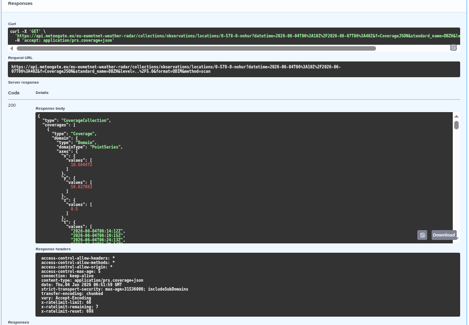
Note: Check the
x-ratelimit-remainingvalue for remaining(anonymous) queries! Get API keys at Meteogate Developer Portalxii. Direct meteogate query link:
https://api.meteogate.eu/eu-eumetnet-weather-radar/collections/observations/locations/0-578-0-nohur?datetime=2026-06-04T06%3A10Z%2F2026-06-04T06%3A40Z&f=CoverageJSON&level=..%2F5.0&format=ODIMNote: Update the datetime field within this URL.xiii. ODIM data are downloadable from these links:
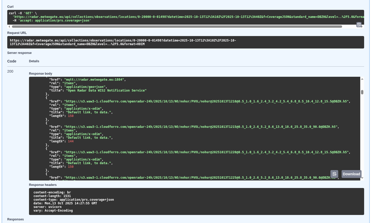
xiv. Using aws tool
    Check the file existing in the S3 bucket:
    ```bash
    aws s3 ls s3://openradar-24h/2026/06/04/NO/nohur/PVOL/   --endpoint-url https://s3.waw3-1.cloudferro.com/  --no-sign-request
    ```
    Check the daily OPERA data in the S3 bucket:
    ```bash
    aws s3 ls s3://openradar-24h/2026/04/06/OPERA/COMP/   --endpoint-url https://s3.waw3-1.cloudferro.com/  --no-sign-request
    ```
    Copy file to new_local_filename.h5:
    ```bash
    aws s3  cp s3://openradar-24h/2026/06/04/OPERA/COMP/OPERA@20260604T0220@0@DBZH.h5 ./new_local_filename.h5  --endpoint-url https://s3.waw3-1.cloudferro.com/  --no-sign-request
    ```
xv. radar_meta(ODIM attributes) section is below the links:
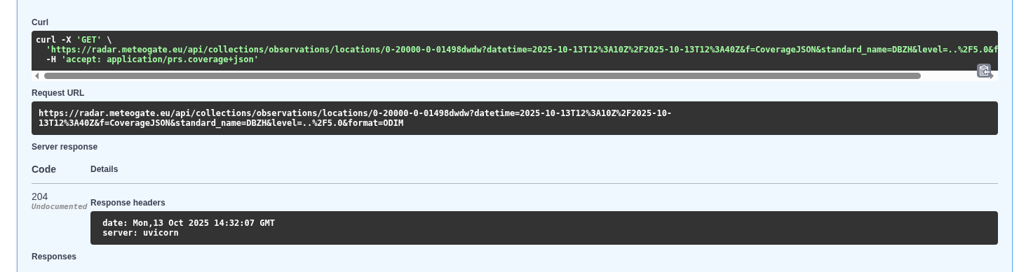
    ```json
        "metocean:wigosId": "0-578-0-honur",
        "metocean:platform_name": "[nohur]",
        "metocean:format": "ODIM",
        "metocean:radar_meta": {
            "object": "PVOL",
            "elangle": 1,
            "nbins": 960,
            "rstart": 0,
            "rscale": 250,
            "nrays": 360,
            "a1gate": 338,
            "product": "SCAN",
            "beamwH": 0.95
        }
    ```
xvi. If no data for the specified query the response is 204.
-
Query Radial velocity volumes:
i.
standard_name: VRADH -
Retrieve all Dutch data.
i.
location_id: 0-528-*-nl*
2. OPERA composite products:
-
Fetch composite product from OPERA production
i.
standard_name: RATE or ACRR or DBZH -
OPERA products:
i.
location_id: 0-20010-0-OPERA -
Query ODIM format:
i.
format: ODIM -
Composite:
i.
method: comp -
OPERA DBZH, products between 06:00 and 06:30 UTC, ODIM format(update the
datetimefield):i.
https://api.meteogate.eu/eu-eumetnet-weather-radar/collections/observations/locations/0-20010-0-OPERA?datetime=2026-07-16T06%3A00Z%2F2026-07-16T06%3A30Z&f=CoverageJSON&standard_name=DBZH&format=ODIMii. S3 link example:
https://s3.waw3-1.cloudferro.com/openradar-24h/2026/07/16/OPERA/COMP/OPERA@20260716T0610@0@DBZH.h5 -
OPERA Accumulated Rain rate products between 06:00 and 06:30 UTC, ODIM format(update the
datetimefield)::i.
https://api.meteogate.eu/eu-eumetnet-weather-radar/collections/observations/locations/0-20010-0-OPERA?datetime=2026-07-16T06%3A00Z%2F2026-07-16T06%3A30Z&f=CoverageJSON&standard_name=ACRR&format=ODIMii. S3 link example:
https://s3.waw3-1.cloudferro.com/openradar-24h/2026/07/16/OPERA/COMP/OPERA@20260716T0700@0@ACRR.h5iii. The API uses the start time of the accumulation interval as the query reference time. However, the object key (file name) in the S3 bucket uses the end of the accumulation interval as its reference time. For example, the file OPERA@20260716T0700@0@ACRR.h5 corresponds to the accumulation interval 06:00–07:00 UTC.
3. Select observation items:
-
Retrieve German sites from boundary box area (-5.5,18.0,72.0,82.1) where raw radar reflectivity data (TH) is available in ODIM format for specific time range (2026-06-04T02:10Z/2026-06-04T02:40Z):
i. Open ORD API and select: collections/observations/items
ii. Click to "Try it out" button and set the query parameters:
iii.
bbox: -5.5,18.0,72.0,82.1iv.
datetime: 2026-06-04T02:10Z/2026-06-04T02:40Zv.
id: leave blankvi.
parameter-name: leave blank, set it below separately (standard_name:level::)vii.
naming_authority: de.dwdviii.
institution,platform: leave blankix.
standard_name: THx.
unit,instrument,level: leave blankxi.
format: ODIM,xii.
method: scanxiii.
period,f: leave blankResult ```json { "type": "FeatureCollection", "features": [ { "type": "Feature", "geometry": { "type": "Point", "coordinates": [ 6.967111, 51.405649, 2.5 ] }, "properties": { "summary": "Radar data from OPERA network.", "license": "https://creativecommons.org/licenses/by/4.0/", "naming_authority": "de.dwd", "platform": "0-276-0-deess", "platform_name": "[deess]", "standard_name": "TH", "unit": "%", "level": 2.5, "period": "PT1M", "parameter_name": "TH:scan", "timeseries_id": "008d7bb60bda9936afc1361e8c2003ae", "radar_meta": { "object": "SCAN", "elangle": 2.4993896484375, "nbins": 720, "rstart": 0, "rscale": 250, "nrays": 360, "a1gate": 80, "product": "SCAN", "frequency": 5606682004.950664, "beamwH": 0.9, "beamwV": 0.9 }, "format": "ODIM", "platform_vocabulary": "https://oscar.wmo.int/surface/rest/api/search/station?wigosId=0-276-0-deess", "method": "scan", "data": "https://api.meteogate.eu/eu-eumetnet-weather-radar/collections/observations/locations/0-276-0-deess?parameter-name=TH:scan&level=2.5&format=ODIM" }, "id": "008d7bb60bda9936afc1361e8c2003ae" }, { "type": "Feature", "geometry": { "type": "Point", "coordinates": [ 8.712933, 49.984745, 5.5 ] }, "properties": { "summary": "Radar data from OPERA network.", "license": "https://creativecommons.org/licenses/by/4.0/", "naming_authority": "de.dwd", "platform": "0-276-0-deoft", "platform_name": "[deoft]", "standard_name": "TH", "unit": "%", "level": 5.5, "period": "PT1M", "parameter_name": "TH:scan", "timeseries_id": "038fe46ffe011e26536f9e45c88a91b2", "radar_meta": { "object": "SCAN", "elangle": 5.4986572265625, "nbins": 720, "rstart": 0, "rscale": 250, "nrays": 360, "a1gate": 54, "product": "SCAN", "frequency": 5641692508.103789, "beamwH": 0.9, "beamwV": 0.9 }, "format": "ODIM", "platform_vocabulary": "https://oscar.wmo.int/surface/rest/api/search/station?wigosId=0-276-0-deoft", "method": "scan", "data": "https://api.meteogate.eu/eu-eumetnet-weather-radar/collections/observations/locations/0-276-0-deoft?parameter-name=TH:scan&level=5.5&format=ODIM" }, "id": "038fe46ffe011e26536f9e45c88a91b2" },... ]... }```